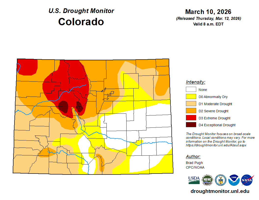
Over 3.5 million Coloradans are within a drought area and 40 counties are experiencing at least D2 conditions currently
Colorado Governor Jared Polis activated the State Drought Task Force on Tuesday, March 17 amid near record-low snowfall in the state’s high country and as above-average temperatures statewide continue to augment drought conditions around the state.
The governor’s announcement, made in a X post, describes parts of Colorado having developed severe drought conditions, including the northern Front Range area and among the Colorado River headwaters, stating that both areas of which “supply critical water resources to key population centers, agriculture and the environment across Colorado’s East and West Slopes.”
Gov. Polis also said 40 counties are experiencing at least D2 conditions (severe drought) according to the US Drought Monitor. The US Drought Monitor estimates 3,571,805 Coloradans are within a drought area currently.
Colorado is experiencing the warmest year so far in our 131-year record, and one of the driest. Activating the Drought Task Force helps protect one of our most precious resources by more closely tracking impacts, supporting communities, and coordinating better as we prepare for… pic.twitter.com/9qk6taHc17
— Governor Jared Polis (@GovofCO) March 17, 2026
“This Water Year has been the state’s warmest start to the Water Year in the Colorado Climate Center’s 131-year record,” Polis said. “Under these circumstances, and based on a recommendation from the WCMC (and others)…I have decided to active Phase 2 of the State’s Drought Response Plan, which includes activation of the state’s Drought Task Force (DTF).”
The State Drought Task Force was lasted activated in 2020, the same year when the state experienced large wildfires in the summer and fall, including the East Troublesome and Cameron Peak fires.
The Governor said as of March 12, statewide average snow water equivalent was at 62% of median average, or the second lowest snow water equivalent level in the past 46 years.
As of March 17, the statewide snow water equivalent level was at 59% of median average with only 8.2 inches of snow water equivalent locked away in the snow – which is 1.4 inches below the historical minimum of 9.6 inches recorded on March 17, 2002.
Colorado has only been using the SNOTEL (Snow Telemetry) system since winter 1986/87. Prior to that, the USDA used snow course measurements to measure snowpack and snow water equivalent levels from around the state.
According to the Colorado Climate Center, using these snow course measurements, only the winters of 1976/77 and 1980/81 had lower snow water equivalent levels than winter 2025/26.
“When comparing the snow water equivalent on February 1st at 62 snow courses with more than 50 years of data, there are eight sites where this year (2026) is the lowest on record,” Colorado Climate Center climatologist Russ Schumacher said in a February 9 article.
Schumacher pointed on that on the map above, the 62 snow courses are shown, with the dark brown circles representing the lowest snow water equivalent rank over the period of record, and that another 14 sites have either the 2nd or 3rd lowest snowpack on record, and several others were in the bottom 10 years historically as well.
If conditions worsen, the governor’s office said it will move the state to Phase 3 of the Drought Response Plan at which point the governor would make an official drought declaration.
Discover more from Rocky Mountain Journal
Subscribe to get the latest posts sent to your email.