Colorado’s first big mountain snow of the season is trending downward, meaning the potential for significant amounts of snow on favorable peaks about 11,000 feet could mostly fall as rain.
According to the National Weather Service in Denver/Boulder, the chance for snow with this week’s system has dropped below 30%, while the real concern has shifted to heavy rain, flash flooding and burn-scar debris flows tied to the remnants of Hurricane Polo.

On Sept. 24, NWS Boulder was flagging a 30% to 50% chance of mountain snow above 10,000 feet late Monday into Tuesday. By Saturday, that had fallen to 10% to 40% above 11,000 feet.
In its Sunday evening discussion, the NWS said snow chances “remain low (<30%)” and limited any accumulation to dustings or lighter amounts above roughly 11,000 feet, and only if colder air arrives Wednesday afternoon through Thursday morning.
The Weather Prediction Center has raised the excessive rainfall risk to “moderate” for the southwest into the southern High Plains on Tuesday into Wednesday.
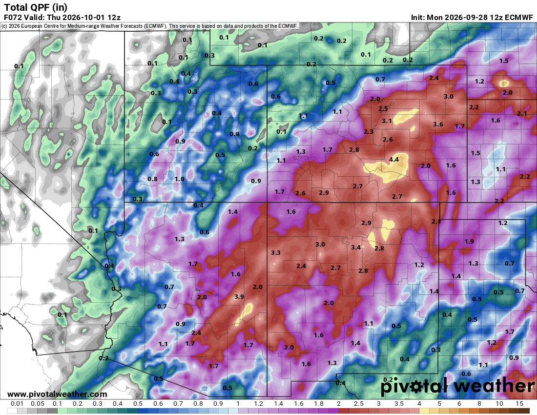
The European Centre for Medium-Range Weather Forecasts forecast from 6 a.m., Monday, Sept. 28 shows areas in southern Colorado, southeastern Colorado and eastern Colorado receiving up to 6 inches of rain by 6 a.m., Thursday, Oct. 1.

Some notable highlights from the season’s first major storm system:
- NWS Boulder puts mountain snow chances below 30%, with any accumulation limited to dustings or light snow above about 11,000 feet
- Precipitable water values could reach 200% of normal as early as Monday afternoon
- The heaviest rain and highest flash-flood concern is expected Wednesday into Thursday, according to NWS Boulder
- A Flood Watch is in effect from Monday morning through Wednesday morning for the Animas River Basin, the northwest and southwest San Juan Mountains, the Uncompahgre Plateau and Dallas Divide, and the Four Corners area
- The Weather Prediction Center has raised the excessive rainfall risk to “moderate” for the Southwest into the southern High Plains on Tuesday into Wednesday
- Low-elevation highs Tuesday hold in the low 70s, with 50s in the mountains
- Drier weather is favored by next weekend as ridging builds over the West
Why the snow forecast faded
NWS forecasters describe the setup as high-impact but low-confidence, with wide model spread. The office said the biggest difference between solutions comes down to where a surface low develops and how it interacts with moisture from Hurricane Polo’s remnants. Solutions that bring intense rain toward the Denver metro develop the low over eastern Colorado, while drier runs delay it until it forms over west-central Kansas.

The latest European model guidance has nudged the heaviest rainfall westward, which is the scenario NWS says would raise the odds of light snow at the very highest elevations. The GFS ensemble has stayed drier for the Denver/Boulder forecast area but has expanded rain into southeast Colorado. Cloud cover and mild temperatures, with mountain highs in the 50s Tuesday, are working against snow at most elevations.
Flood risk shifts to the San Juans and southeast Colorado
The burn-scar flood threat is now the most concrete hazard on the board.
The Flood Watch for southwest Colorado warns of flooding over burn scars, at low-water crossings and along creeks and washes, with unpaved roads possibly becoming muddy and impassable. Communities named in the watch include Telluride, Ouray, Silverton, Pagosa Springs, Durango and Cortez.

According to the Weather Prediction Center, a slight westward shift in the track of Polo’s remnants has the corridor of heaviest rain moving up the eastern half of New Mexico and spreading very heavy rainfall north into the San Juans and the Sangre de Cristo range along the New Mexico-Colorado border. NWS Boulder also says confidence is increasing for more substantial rain in southeast Colorado, and possibly Lincoln and Elbert counties.
What it means for mountain roads and ski areas
- Roads: Any snow that falls would likely stay above about 11,000 feet, meaning slush and reduced visibility are the main risks on the highest passes, rather than heavy accumulation. The bigger threat is water and debris over roadways in the San Juans, including areas near recent burn scars. Drivers should check cotrip.org for closures before heading into the southwest mountains.
- Ski areas: No forecast source reviewed for this story called for meaningful accumulation at any Colorado ski area. The highest-elevation resorts could see a dusting on upper terrain if the colder scenario plays out, but that would be a scenic snow, not a skiable one.
- Fall colors: Rain and wind could strip aspens in some areas, a factor for leaf-peepers planning trips this week.
What to watch
Forecasters say the details won’t come into focus until the system is closer.
The key questions are the track of the upper low, how much of Polo’s moisture wraps around the surface low, and whether temperatures are cool enough Wednesday afternoon into Thursday morning for snow at the highest elevations.
NWS Boulder says longer-range ensembles favor drier weather returning by the weekend, with temperatures near or below seasonal averages through the next 10 days.
Discover more from Rocky Mountain Journal
Subscribe to get the latest posts sent to your email.