Several mountain ranges in both Colorado and Utah saw unusually low snowfall since Oct. 2025.
According to NASA Earth Observatory, the agency is currently observing a snow drought affecting the western United States.
In an article from Monday, April 27, Lindsey Doermann, Science Systems and Applications staffer pointed out that, “the lack of mountain snowpack has resource managers on alert going into the warmer months.”
This news comes after the western U.S. experienced one of the driest winters in both the SNOTEL and snow course measurement eras.
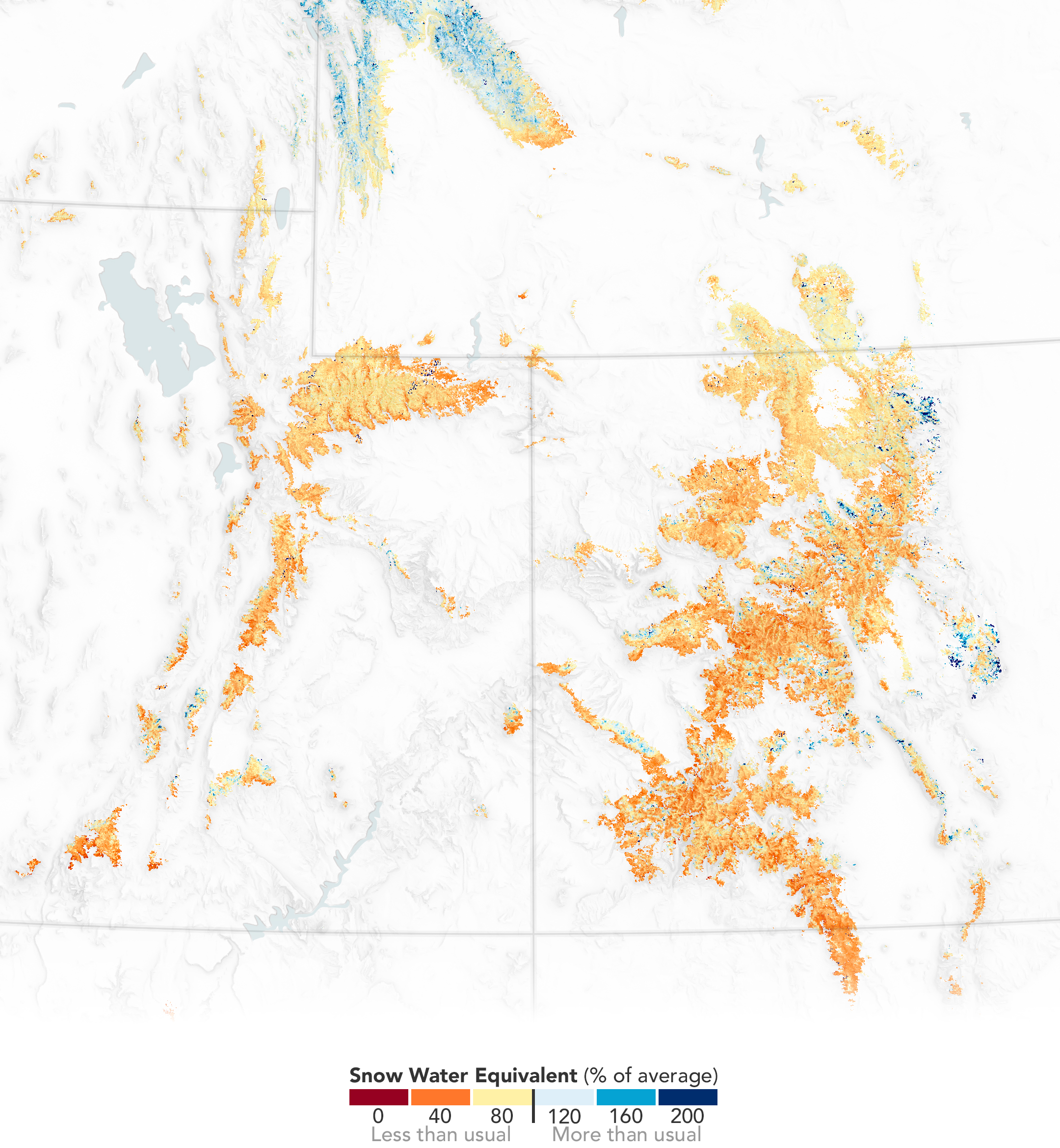
Doermann’s report highlighted SWE levels in the Upper Colorado River basin, showing how severe the snow drought is in Colorado and Utah.
The map below showed how much water was stored in the snowpack on March 15 in winter 2025/26 compared to the 2001-2025 average, according to Doermann.
Nearly all of Utah was showing ‘Less than usual’ SWE % of average levels and the vast majority of Colorado was displaying similar SWE levels on that date.
Doermann said to come to the estimates of SWE levels, researchers at the Institute of Arctic and Alpine Research (INSTAAR) combined data from instruments on NASA’s Aqua, Terra, and Landsat satellites, as well as ground-based snow sensors and a data assimilation model called the Land Information System.
Doermann said the instruments group provides regular, near-real-time snowpack reports to water managers, government agencies, tribes and other stakeholders in Colorado, California and other western states throughout each melt season.
Upper Colorado River basin snowpack peaked in early March, a full month ahead of the average peak date of April 8. According to Doermann, SWE topped out much earlier than normal across all western states, as reported by the National Integrated Drought Information System (NIDIS).
Doermann said the Colorado Basin experienced its warmest March on record, according to NIDIS data, with temperatures 13.7 degrees Fahrenheit (7.6 degrees Celsius) above normal.
Furthermore, snow cover in the western U.S. plunged in the second half of March due to the heatwave, dropping below 250,000 km2 as March began.

Doermann also noted that January and February 2026 also had the lowest snow cover for those respective months, in the MODIS record, despite widespread snowstorms in the third week of February.
“Snow-covered area across the western United States was 38% of average for February, according to the National Snow and Ice Data Center (NSIDC), ranking last in the 26-year satellite record,” she said.
The most pronounced effects of the snow drought are expected in areas experiencing consecutive years of drought or snow drought, the NIDIS said.
This includes areas around the Rio Grande and the Pacific Northwest — where a statewide drought was declared in Washington — as well as the Upper Colorado.
Downstream, Lake Powell, which is fed by the rivers of the Upper Colorado Basin and impounded by the Glen Canyon Dam in northern Arizona, has dropped to near-historic low levels and was 24 percent full as of April 19, 2026, according to Doermann.
The Bureau of Reclamation, which manages the dam, projects that the lake could fall below the minimum level needed to produce power by August 2026 “without major intervention,” according to an April 17 news release.
The Bureau of Reclamation started releasing water from Flaming Gorge Dam on May 1, with flows at full power plant capacity, currently 4,600 cfs, according to the Bureau of Reclamation.
On May 4, Reclamation implemented a larval trigger study plan release, which included additional bypass releases (+4,000 cfs), with flows totaling up to 8,600 cfs.
The reservoir in southwestern Wyoming is expected to drop 12 feet by September.
Discover more from Rocky Mountain Journal
Subscribe to get the latest posts sent to your email.